

{lessontitle}
3.7 Non-Convective LLWS
Forecasts of Low Level Wind Shear (LLWS) in TAFs will only refer to non-convective LLWS. (LLWS is always assumed to be present in convective activity). LLWS will be included in TAFs when it currently exists or is expected to occur from the surface up to and including 2,000 feet AGL.
LLWS example:
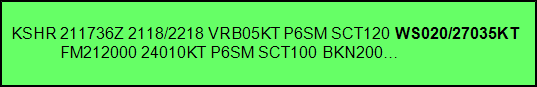
LLWS is included in a TAF after the cloud group using the contraction "WS". The format of non-convection LLWS is: WShwshwshws/dddffKT, e.g., "WS020/27035KT".
| Non-Convective Low Level Shear Format | Example | |
| WS | Indicator | WS |
| hwshwshws | Upper height (in feet) above the surface of the wind shear layer. LLWS is forecast to be present from the surface to this level. | 020 = 2000 feet |
| ddd | Wind direction at the top of the wind shear layer. | 270 = wind from 270 degrees |
| ff | Speed in knots of wind at the top of the wind shear layer. | 35 = 35 knots |
| KT | Unit indicator for winds in knots | KT |
Additional points on using LLWS in TAFs:
- LLWS will not be included in a TEMPO or PROB30 group.
- Once included in the TAF, LLWS remains as a prevailing condition until the next "FM" group or the end of the TAF valid period if there are no subsequent "FM" groups.
- LLWS should be included in the TAF when one or more PIREPS (Pilot Reports) have been received which indicate an air speed loss or gain of 20 knots or more within 2,000 feet of the surface.