{lessontitle}
3.6 Clouds or Obscurations
A cloud or obscuration group will be included in the initial forecast time period and any subsequent FM (from) groups to indicate:
- the cumulative amount of all cloud layers in ascending order and height,
- or to indicate vertical visibility into a surface-based obstruction,
- or to indicate a clear sky
The sky cover categories are defined as:
| Sky Cover Categories | |
| Sky Cover Contraction | Sky Coverage |
| SKC | 0 oktas |
| FEW | 1 to 2 oktas |
| SCT | 3 to 4 oktas |
| BKN | 5 to 7 oktas |
| OVC | 8 oktas |
Cloud heights are forecast in hundreds of feet AGL using the following resolution.
| Cloud Height Resolutions | |
| Height Values | Increments |
| < 3,000 ft AGL | To nearest 100 ft |
| > 3,000 to < 5,000 ft AGL | To nearest 500 ft |
| > 5,000 ft AGL | To nearest 1,000 ft |
Here are some rules for cloud layers:
| Description | Example |
| The number of cloud layers per forecast group should not exceed three. | ...-SHRASN SCT012 BKN030 OVC050 |
| Only one SCT or FEW layers should be included. | ...FEW001 OVC003 |
| Cloud layers above 15,000 feet should be omitted if a broken or overcast layer is forecast below 15,000 feet. | ...SCT035 BKN100 |
| When clear skies are forecast, the cloud group is coded as SKC. | ...P6SM SKC |
| If thunderstorms are forecast, (even in the vicinity), a cloud type of "CB" will be appended to the cloud layer which is associated with the base of the cumulonimbus cloud. | ...-TSRA SCT020CB BKN035 |
Note: The cloud type (CB) will not be used in the TAF unless TS or VCTS is included in the present weather accompanying the visibility.
Vertical Obscurations
To indicate the sky hidden by surface-based or aloft weather phenomena, the contraction "VV" (vertical visibility) is used to forecast the vertical visibility in hundreds of feet AGL into the obscuration.
| Description | Example |
| The vertical visibility (VV) is followed by the visibility in hundreds of feet. | ...VV005 (denotes a vertical visibility of 500 feet) |
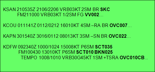
Examples: