National Weather Service Training Center
Basic Hydrologic Concepts
Section IV
Rainfall/Runoff Relationships
Introduction
Converting rainfall to runoff is one of the most important components of the hydrologic cycle. Runoff traveling overland to the stream channel is surface or direct runoff. It makes up the majority of flow when a flood occurs.
Lesson Objectives
Upon completion of this module, be able to explain what happens to rainfall when it reaches the ground and describe the factors affecting the amount of runoff for particular storm. Specifically, you will be able to:
· Describe what happens to rainfall when it reaches the ground.
· Define how various factors affect the amount of runoff to be expected.
· Define the procedure that the RFC uses to estimate runoff HSA’s.
Rainfall and Runoff
Surface runoff is the part of the rainfall traveling overland to the stream channel. Water from surface runoff makes up most of the flow during a flood event.
When rainfall reaches the ground, the water will either:
- Travel overland to the stream channel
- Infiltrate into the soil mantle
- Evaporate back into the atmosphere
Water that travels overland to the stream channel is surface or direct runoff. Surface runoff reaches the stream very quickly. Surface runoff combined with rain falling on the stream channel make up the majority of flow during a flood.
Water that infiltrates into the soil mantle moves by gravity. The water moving laterally and reaching the stream channel, usually several days after the rain occurs is interflow.
Some of this water percolates down to the groundwater. The groundwater may reach the stream channel long after the water infiltrates into the soil. Combine groundwater flow and interflow into a single baseflow term.
The amount of runoff, from both surface runoff and baseflow, varies from storm to storm and from location to location.
The estimation of surface runoff is the challenge for hydrologists in predicting river flows. The following factors will cause the amount of surface runoff to vary:
- Soil moisture - At the onset of rainfall, the higher the soil moisture content, the higher the percentage of rainfall that results in runoff. Flash flood guidance is a measure of soil moisture. Lower flash flood guidance values indicate more moisture in the soil.
- Soil type - Soils made up of fine materials such as clay have low porosity and low infiltration capacity.
- Infiltration capacity is the soil’s ability to accept water. For two identical storms, soils with low infiltration capacity generate more surface runoff than soils with high infiltration capacity. Infiltration capacity also depends on soil moisture. As soils become wetter, infiltration capacity decreases.
- Infiltration rates for fine soils such as clay are around 0.2 inches per hour. Infiltration rates for sandy soils range from 0.5 to 3 inches per hour.
- Slope - The steeper the slope of a watershed, the higher the percentage of rainfall becomes surface runoff. The steeper the slope of a watershed, the higher the velocity of water as it travels overland and less time is available for water to infiltrate into the soil.
- Vegetation - Dense low-lying vegetation in watersheds will retard flow, allow more time for water to infiltrate into the soil, and result in more runoff that soils with little or no vegetal cover.
- Rainfall intensity - Storms with high rainfall intensity (convective storms) will produce a greater percentage of runoff than a storm of the same amount with a lower intensity (stratiform precipitation).
- Time of year – For storms of similar intensity, duration, and amount, winter storms generate more surface runoff than in the summer. In the winter, evaporation is less, and soils stay wetter longer.
- Amount of rainfall - As the storm total precipitation increases, the percentage of surface runoff occurring increases.
The generation of runoff is not a linear process. This means that if the rainfall intensity doubles, the amount of runoff will not necessarily be doubled.
There are numerous models used to estimate the amount of runoff from a rainfall event. The models the NWS uses are either statistically based to estimate runoff based on the time of year, rainfall amount, and soil moisture content or are computer programs that simulate the movement and occurrence of water on the soil surface and the top layer of the soil.
Sacramento Soil Moisture Accounting (SACSMA) Model
The most commonly used computer model is the Sacramento Soil Moisture Accounting Model. It uses 17 parameters to simulate water in the soil and on its surface. The SACSMA assumes basins are relatively homogenous and all parameters averaged over the basin again. The SACSMA, with 17 parameters, has a relatively long memory. It attempts to use a physical approach.
Methods such as SACSMA or the Antecedent Precipitation Index (API) Model only estimate the amount of surface runoff expected for a given storm. Use other hydrologic techniques to determine the discharge at the outlet of a river basin.
The SACSMA Model:
- Uses 17 parameters to simulate water in the soil and on its surface
- Assumes basins are relatively homogenous and averages all parameters over the basin
- Long “memory”
Antecedent Precipitation Index (API) Model
The most often used statistical relationship in the NWS is the Antecedent Precipitation Index (API) model.
The Antecedent Precipitation Index (API) model correlates:
· Time of year
· Rainfall amount
· Rainfall intensity
· Indicator of soil moisture to estimate runoff
Antecedent Precipitation Index Model
Sample Problem
1. Using the above Figure, determine the surface runoff that will result from a storm that occurred during the 52nd week of the year with a 24-hour duration, 5.5 inch basin average rainfall, and API at the beginning of the storm of 0.8.
2. From the coaxial relationship, the surface runoff is 3.8 inches. (Follow the "darkly arrowed" path through the coaxial quadrants.)
3. Compute the surface runoff expected from the same storm in number (1) above that occurred during week 33.
4. Relate week 52 in late December runoff to the runoff during week 33 in mid-August.
The runoff during week 52 is much higher and is consistent with the fact that more runoff occurs during the winter than the summer.
API Exercise and Questions
1. Using the coaxial rainfall-runoff relationship in the above figure, determine the surface runoff expected from a 4-inch rainfall event of 24-hour duration the last week in December (week number 52). The soil moisture condition is very wet with an API of 2.0.
Expected Runoff = __________inches
2. Using the information from problem 1, how much runoff occurs when extremely dry conditions (API of 0.5) exist?
Expected runoff = ___________inches
3. At a particular gaging site, 1 inch of runoff produces minor flooding, and closes some secondary roads. After a prolonged dry period (API of 0.3) in August (week number 33), a tropical storm is expected.
How much rainfall in a 12-hour period will it take to cause flood problems?
Rainfall for 1 inch of runoff =__________ inches.
4. At the site in question 3, how much rainfall would it take to cause flood problems if it is wet (API 2) in the last week in February (week 8)?
Rainfall for 1 inch of runoff =___________ inches.
5. For a 24-hour rainfall event during week 5 or week 12 and an API of 0.5, 2 inches of rainfall produces about 1.1 inches of runoff. Four (4) inches of rainfall produces about 2.8 inches of runoff. The rain amount doubled, but the runoff for 4 inches of rain is over 12 times the 2-inch rainfall amount. Why?
Typical Infiltration Rates at the End of 1 hr (f1)
Soil Group
· High (sandy soils): 0.50 - 1.00 (in/hr)
· Intermediate (loams, clay, silt): 0.10 - 0.50 (in/hr)
· Low (clays, clay loam): 0.01 - 0.10 (in/hr)
Questions
a) Which soil type would have more runoff, why?
b) Which soil type would have the least runoff, why?
Answer to the Exercises and Questions
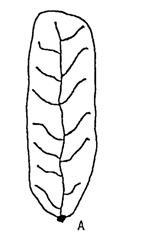
Typical Stream Types and Stream Systems
| Image | Stream Systems | Characteristics |
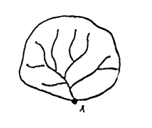 |
Dendritic |
Numerous small tributaries joining at right angles to higher order streams. Common in the Appalachians and the foothills of the Rockies. |
 |
Trellis |
Long main streams intercepted by numerous shorter right angle tributaries. Common in the Appalachians and the foothills of the Rockies. |
 |
Radial |
|
 |
Multi-basin System |
Low gradient, swampy areas; glaciated, windblown, permafrost areas. Common in plains and mountain valleys. |
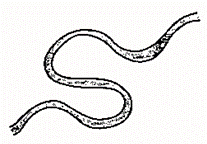 |
Meandering |
Result of transverse currents; result of forces acting on stream particles, streambed and stream banks. |
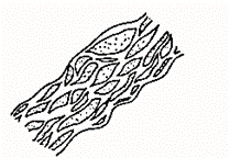 |
Braided |
Numerous interconnected channels flowing over islands and bars…generally transport large amounts of sediment. |
Source: Viessman, Knapp, Lewis, and Harbaugh, "Introduction to Hydrology", pg. 152
Return to the Basic Hydrologic Concepts Menu of Lessons
Updated 07/18/07