

3.6 Web Maps
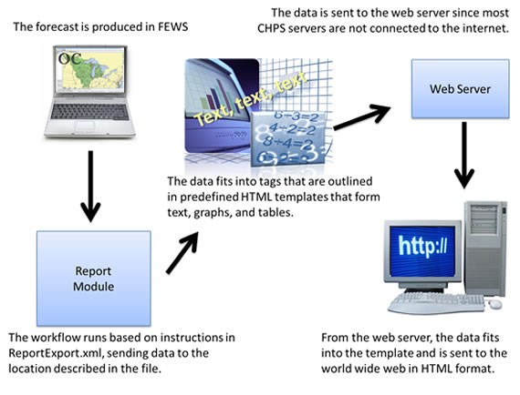
River Forecast Centers relay information directly to the public through their web sites. The CHPS report module can help you send information from FEWS to a web server in HTML format.
Report Module
The focal point customizes the templates to format the data. The report module puts the data into the desired format, generates the reports from FEWS, and displays the reports in HTML format. The report templates can organize the information into text, charts, and tables. The maps can be exported and sent to a web server.
Setting up the Module
The image below is snippet of code from the ReportExport.xml file, the first step in the process listed below.
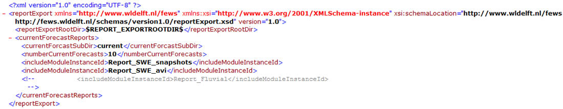
Hint: Click the image to enlarge/shrink.
Generating the first report requires the Configuration Focal Points to follow several steps. After the initial set up is finished, the process is as simple as running a workflow. The process involved includes:
- Set up a workflow to generate the report data
- Register the workflow
- Write the reports configuration file
- Create an HTML template
- Synch report output to the RFC web server for distribution to the web
For detailed instructions, see the job sheet below or click on the link to the Deltares wiki.
Exporting Maps
The report module takes data exported from FEWS and converts it to a format viewable without CHPS. The Configuration Focal Point sets up the process to send the map to the web server.
The file is saved in the /bin directory and is named currentmap.png. If you use the map with the report module, remember to include the map in the description of the report in the configuration file.
Synch the map and the report to your LDAD and send it to the RFC web server from there.
For more instructions on generating reports, use the job sheets below.
Job Sheet: Configuring the Report Module
References: Information from the Deltares wiki on the Report Module and Report Export