

3.5 PCRaster
You can create additional products using third party software. PCRaster is an example of outside software RFCs can use with CHPS data to create gridded data, such as Flash Flood Guidance (FFG).
PCRaster, a type of environmental modeling software, utilizes GIS to create simulation models such as runoff models. No license is required for the software. Learn more about the software on the PCRaster web site.
PCRaster is also an efficient way of running model calculations for a large number of grid cells.
Connecting CHPS to PCRaster
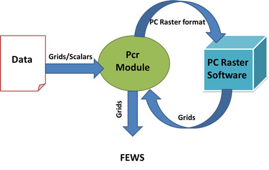
Transformation Module
The pcrTranformation module creates a direct link between FEWS and PCRaster.
The transformation module sends information to the PCRaster model. After the model runs, the transformation module reads and prepares the output to go back into CHPS. The data becomes available and is viewable in the IFD.
Configuring PCRaster
The schemas required for PCRaster, pcRaster.xsd and pcrTransformationSets.xsd are included by default, so configuration is limited to changing the module configuration file containing the pcraster code.
Considerations
- The units are the same as what is specified in the Parameters.xml file.
- Make sure the variables and constants are the same units.
- Define all variables you need after the model runs at the top of the file, rather than in the program. The results from the variables are stored in memory and will NOT be available after the model run unless defined in Parameters.xml!
Use the following job sheet to help you configure PCRaster to create gridded output from CHPS.
Job Sheet: Configuring PCRaster
Reference: pcrTransformation module (Deltares wiki)