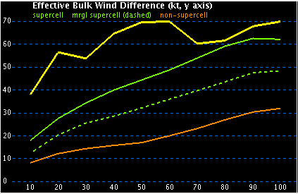
Effective Bulk Wind Difference
The effective bulk wind difference is the magnitude of the vector wind difference between the effective inflow layer and the any higher point above in the sounding. The display shows the effective bulk wind difference at every level from the effective inflow layer (0% of storm depth) to the equilibrium level (100% of storm depth). It also displays reference traces of effective bulk wind differences for different storm types (non-supercell, marginal supercell, and supercell).
Compare the yellow current trace to the green and orange reference traces to investigate potential storm types.
x-axis - percentage of storm depth (%) ranging from 10% to 100%
y-axis - bulk wind difference in knots ranging from 0kts to 70 kts
yellow trace - current displayed sounding bulk wind differences
orange trace - non-supercell reference bulk wind differences (discrete storms with no significant rotation)
dashed green trace - marginal supercell reference bulk wind differences (rotational velocity < 20 kts or persists less than 30 min)
solid green trace- supercell reference bulk wind differences (rotational velocity > 20 kts and persists more than 30 min)