

Collaborative Convective Forecast Product (CCFP)
 The Collaborative Convective Forecast Product (CCFP) is a strategic forecast of convection to provide decision support to air traffic managers in their quest to manage traffic in the National Airspace System (NAS).
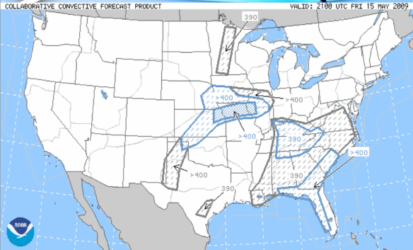
Tip: Click the image to the left to enlarge/shrink.
The purpose of the CCFP is to aid in the reduction of air traffic delays, reroutes and cancellations influenced by significant convective events. The CCFP is a forecast of expected convective weather at 4, 6 and 8 hours after the issuance time. It is issued every 2 hours.
CCFP is defined as polygon of at least 3000 square miles that contains:
- Coverage of at least 25% with echoes of at least 40 dBZ composite reflectivity;and
- Coverage of at least 25% with echo tops of FL250 or greater; and
- Forecaster confidence of at least 25%.
Forecaster's confidence level that the conditions will occur in the forecast polygon are divided into two classes:
- Low = 25 - 49% (CCFP polygon identify by grey border and fill)
- High = 50 - 100% (CCFP polygon identified by blue border and fill)
Each CCFP is produced by the Aviation Weather Center after collaborating with the CWSUs, airline meteorological offices and the Meteorological Service of Canada.
Once the final product is produced, each CCFP is posted on the Aviation Weather Center (AWC) web site at: http://aviationweather.gov/products/ccfp/
The CCFP is a seasonal product. They are issued starting March 1 and end on October 30.