
One of the goals of fieldwork is verifying the information in the E-19.
Getting Started
Make a copy of the previous E-19. Compare photos of the gage location to images in Google Earth. Note any changes to development and land use.
Log into HADS to check the GOES ID. The identifier typically only changes if the gage equipment has changed significantly.
Contact the gage owner for the latest version of the station description. Note any differences in the equipment, benchmarks, latitude, longitude, or elevation.
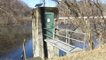
At the Gage Site
Locate the benchmarks using the previous E-19 or the latest station description. Document the datum you are using for the GPS. What appears to be errors in the latitude, longitude, or elevation could be datum differences.
Photograph up and downstream of the gage. Take updated pictures around the gage site, noting new buildings or bridges. Also photograph the interior and exterior of the gage house. Note any equipment changes.
Use surveying equipment and check the accuracy of the impact statements. Obtain levels for potential impacts not listed on the previous E-19.
Note: Check the accuracy of the driving directions to the gage. Typically, this information is not included in an E-19, but is very important nonetheless.
Back at the Office
Make necessary changes in HydroBase. Print a new copy of the E-19 for all offices on the distribution list. Include a cover sheet with a list of changes from the previous E-19.
Reference: NWSI 10-924 WFO Water Resources Reporting